The Master in Remote Sensing was created under Decree number 1216-A dated January 7, 2011, has a professional orientation, with an academic, scientific and technological focus. It is accredited for the period 2019-2026 in the six criteria considered by the National Accreditation Commission (CNA): conceptual definition, institutional context, characteristics and results of the program, academic body, support resources and self-regulatory capacity.
Aimed at professionals in earth sciences linked to the planning, management and monitoring of natural resources and the environment, land-use planning, and who hold the academic degree or equivalent professional title in level. These include: geophysicists, geographers, geologists, geomensors, geomatics, topographers, photogrammetry specialists, biologists, cartographers, agronomists, forest engineers, environmental, systems and communications engineers.
Graduate Profile
Graduates of the Master’s Program in Remote Sensing at Universidad Mayor are professionals with the knowledge and skills needed to extract data and analyze information from imagery acquired by multispectral, hyperspectral, thermal, LiDAR, and RADAR remote sensing systems. They also use this information in an integrated way to study and understand our environment with greater accuracy and completeness.
They are able to:
a) Evaluate and integrate models of multitemporal and spatial change, considering different sources of geographic information.
b) Propose methodological strategies for planning, managing, and monitoring the Earth’s surface using data derived from remote sensors.
c) Apply image-processing techniques to data acquired by active and passive sensors in order to address environmental and territorial challenges, as well as change processes.
d) Apply remote sensing techniques to propose methodological solutions for developing projects in different professional fields, aimed at the public and private sectors, focused on environmental issues.
General Objective
To train professionals from diverse backgrounds in the use of technological tools in remote sensing, capable of innovating, understanding, and proposing solutions to complex environmental and territorial situations, as well as change processes related to their area of study.
Specific Objectives
a) Apply processing and analysis techniques to images acquired by active sensors (RADAR and LiDAR) and passive sensors (multispectral, hyperspectral, and thermal) to address environmental and territorial issues and change processes.
b) Understand and know how to use remote sensing techniques for planning, managing, and monitoring the Earth’s surface using information derived from remote sensors.
c) Integrate remote sensing knowledge with labor-market needs, identify demands and opportunities in the public and private sectors that require specialized expertise, and be able to identify suitable resources while developing cooperation skills with professionals from diverse fields.
Development Areas:
a) Digital image processing
This line groups topics focused on the processing, correction, information extraction, and analysis of remote sensing images.
b) Geodata modeling and analysis
This line focuses on the management, integration, modeling, and spatial analysis of geographic data derived from remote sensing and other sources.
c) Applied remote sensing
This line groups topics focused on the use of remote sensing to address issues in different territorial, environmental, and productive contexts.
The program has the following competitive advantages:
a) It develops an integrative approach to the application of Earth observation systems, establishing itself as a unique offering at the national level (in place since 2012).
b) Students take part in the faculty’s I+D+i+e projects, and the program encourages the publication of capstone/thesis projects in indexed journals.
c) Active collaboration with national and international partners of the HÉMERA Center, which facilitates the development of capstone/thesis projects and training opportunities for students with academic excellence.
d) Student participation in international opportunities (conferences, internships, and courses).
e) Admission of students from other regions and from abroad (synchronous modality).
f) Ongoing participation of international faculty as collaborators and/or visiting lecturers.
g) Articulation with the Doctorate in Geomatics Engineering at the Universitat Politècnica de València (UPV, Spain), facilitating graduates’ academic progression.
h) It stands out for its alignment with the National Satellite System (SNSat), a national initiative that brings together sectoral ministries, academia, and the Chilean Air Force, aimed at strengthening space capabilities with a direct contribution to national development.
Program Director: Dr.© Waldo Pérez Martínez / waldo.perez@umayor.cl
Academic Coordinator: Dr. Paul Amouroux / paul.amouroux@umayor.cl
Más información [Link]
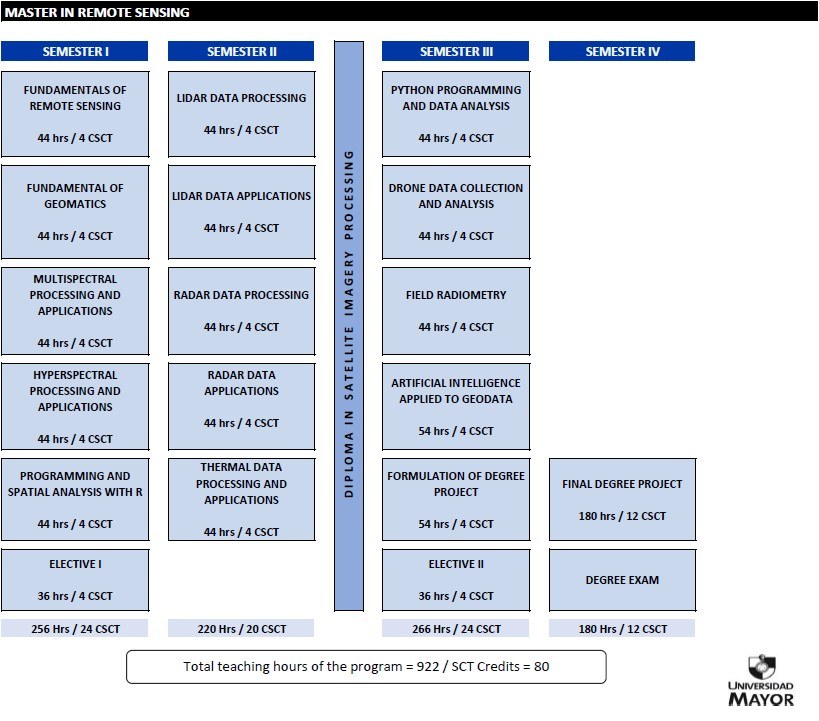
Curricular Contents Master in Remote Sensing:
TEACHING STAFF
-Program Director
Waldo Pérez Martínez
Geographer, Pontificia Universidad Católica de Chile.
Master in Coastal and Estuarine Zone Management, Universitat Politècnica de Catalunya, Spain.
Dr.© in Geomatics Engineering, Universitat Politècnica de València, Spain.
Currently he is the director of HÉMERA Earth Observation Center, General Direction of Research and Artistic Creation, Vice Rector's Office for Research, undergraduate and postgraduate professor at the Faculty of Science, Engineering and Technology, Universidad Mayor.
-Academic Coordinator
Paul Amouroux
Agronomist, ISARA, Lyon, France.
Master in Environment and Sustainable Development, AgroParisTech, France.
Dr. in Population Biology, Université de la Réunion, France.
Currently he teaches undergraduate and graduate courses at the Faculty of Science, Engineering and Technology, and is a researcher at HÉMERA Earth Observation Center, General Direction of Research and Artistic Creation, Vice-Rectory of Research, Universidad Mayor.
-METE 1301: Fundamentals of Remote Sensing
Abel Calle Montes
Degree in Physics, University of Valladolid, Spain.
Dr. in Physics, specializing in Physics of the Atmosphere, University of Valladolid, Spain.
He has been coordinator of the Physics degree, director of the Applied Physics Department and Vice-Rector of Academic Planning at the University of Valladolid (UVa). He was also co-founder of the spin-off company “Deimos Imaging” which implemented the first Spanish Earth observation satellite.
He currently teaches in the Degree in Physics and the Master in Atmosphere and Climate of the Faculty of Sciences and is a researcher of the Atmospheric Optics Group (GOA) of the UVa, official calibration center of NASA's AERONET network for measuring atmospheric aerosols, where he has conducted two Antarctic campaigns.
He is currently director of the Lower Atmosphere Research Center (CIBA), at UVa, which hosts an international ICOS (Integrated Carbon Observation System) station to carry out the inventory, managed by the IPCC, of greenhouse gases with projection to climate change studies.
-METE 1302: Fundamentals of Geomatics
Paulina Vidal Páez
Geographer, University of Chile.
Diploma in Geomatics and Satellite Technology, Universidad Mayor, Chile.
Master in Remote Sensing, Universidad Mayor, Chile.
Dra.© in Geomatics Engineering, Universitat Politècnica de València, Spain.
Currently she teaches undergraduate and graduate courses at the Faculty of Science, Engineering and Technology, and is a researcher at HÉMERA Earth Observation Center, General Direction of Research and Artistic Creation, Vice Rector's Office for Research, Universidad Mayor, Chile.
Enrique Arce Muñoz
Forestry Engineer, Universidad Mayor, Chile.
Diploma in Geomatics and Satellite Technology, Universidad Mayor, Chile.
Master in Remote Sensing, Universidad Mayor, Chile.
Currently he is a professor director of the School of Forestry Engineering, undergraduate and postgraduate professor of the Faculty of Science, Engineering and Technology, Universidad Mayor, Chile.
-METE 1303: Multispectral Processing and Applications
Blanca Ríos Ramos
Environmental Engineering, Universidad Autónoma Metropolitana, Mexico.
Master in Earth Sciences, Universidad Nacional Autónoma de México.
Dr. in Earth Sciences, Universidad Nacional Autónoma de México.
Postdoctoral associated with the Institute of Atmospheric Sciences and Climate Change, National Autonomous University of Mexico.
Currently she teaches undergraduate and graduate courses at the Faculty of Science, Engineering and Technology and is a researcher at HÉMERA Earth Observation Center, General Direction of Research and Artistic Creation, Vice-Rectory of Research, Universidad Mayor.
-METE 1304: Hiperespectral Processing and Applications
María Dolores Raya Sereno
Degree in Environmental Sciences, University of Córdoba, Spain.
Master in Planning and Management of Territorial and Local Development, University of Seville, Spain.
Dr. in Agro-environmental Technology for Sustainable Agriculture, Universidad Politécnica de Madrid, Spain.
Currently she is a postdoctoral researcher at the Environmental Spectroradiometry and Remote Sensing Laboratory (SpecLab), Institute of Economics, Geography and Demography (IEGD), Spanish National Research Council (CSIC), Spain.
-METE 1305: Programming and Spatial Analysis with R
Benedikt Johann Hora
Bachelor of Science - Geography, Universität Innsbruck, Austria.
Master of Science - Geography: Global Change - Regional Sustainability, Universität Innsbruck, Austria.
Dr. in Geography, Universität Innsbruck, Austria.
Currently serves as an undergraduate and graduate lecturer in the Faculty of Science, Engineering and Technology and as an associate researcher at the Center for Resilience, Adaptation and Mitigation (CReAM), General Directorate for Research and Artistic Creation, Vice-Rectorate for Research, Universidad Mayor.
-METE 1307: LiDAR Data Processing
Pablo Crespo Peremarch
Technical Engineer in Topography, E.T.S de Ingeniería Geodésica, Cartográfica y Topográfica, Universitat Politècnica de València, Spain.
Engineer in Geodesy and Cartography, E.T.S de Ingeniería Geodésica, Cartográfica y Topográfica, Universitat Politècnica de València, Spain.
Master in Software Engineering, Formal Methods and Information Systems, Universitat Politècnica de València, Spain.
Dr. in Geomatics Engineering, Universitat Politècnica de València, Spain.
Currently he is a researcher in the Geoenvironmental Cartography and Remote Sensing Group (CGAT), Department of Cartographic Engineering, Geodesy and Photogrammetry, Universitat Politècnica de València, Spain.
-METE 1308: LiDAR Data Applications
Jesús Torralba Pérez
Forestry and Environmental Engineer, University of Castilla-La Mancha, Spain.
Diploma in Geomatics and Satellite Technology, Universidad Mayor, Chile.
Master in Remote Sensing, Universidad Mayor, Chile.
Dr.© in Geomatics Engineering, Universitat Politècnica de València, Spain.
Currently he is a senior research technician in the Geoenvironmental Cartography and Remote Sensing Group (CGAT) of the Department of Cartographic Engineering, Geodesy and Photogrammetry of the Universitat Politècnica de València.
-METE 1309: Radar Data Processing
Matías Ernesto Barber
B.Sc. in Physics, University of Buenos Aires (UBA), Argentina.
Ph.D. in Physics Science, specializing in Radar Remote Sensing, University of Buenos Aires (UBA), Argentina.
Postdoc in Radar Remote Sensing, Instituto de Astronomía y Física del Espacio (IAFE - CONICET/UBA), Argentina.
Currently, he is adjunct researcher at CONICET, Technology area (KT1) and lecturer at the School of Engineering, University of Buenos Aires (UBA), Argentina.
-METE 1310: Radar Data Applications
Patricia Alejandra Rosell
Engineer Surveyor, Universidad Nacional del Sur (UNS), Argentina.
Dr. in Science and Technology, National University of Cuyo (UNCuyo), Argentina.
Currently she is a postdoctoral fellow of CONICET at the Institute of Special Training and Development of Computer Aided Engineering (CEDIAC-UNCuyo) and as a teacher-researcher in the areas of Geodesy and Remote Sensing at the Universidad Juan Agustín Maza (UMaza), Universidad Nacional de Cuyo (UNCuyo) and Universidad Nacional del Comahue (UNComa), Argentina.
-METE 1311: Thermal Data Processing and Applications
Cristina González Haro
Telecommunications Engineer, Universitat Politècnica de Catalunya, Spain.
Master in Information and Communication Technologies Research, Universitat Politècnica de Catalunya, Spain.
Dr. in Signal and Communication Theory, Universitat Politècnica de Catalunya, Spain.
Currently, she is a research scientist at the Department of Physical and Technological Oceanography, Institut de Ciències del Mar (ICM) of Barcelona, Spanish National Research Council (CSIC).
-METE 1312: Python Programming and Data Analysis
Víctor Aliaga Tobar
Biotechnologist, Universidad Iberoamericana de Ciencias y Tecnología, Chile.
Dr. in Integrative Genomics, Universidad Mayor, Chile.
Currently he teaches undergraduate and graduate courses at the Faculty of Science, Engineering and Technology, and is a researcher at the Center for Genomics and Bioinformatics (CGB), General Direction of Research and Artistic Creation, Vice-Rectory of Research, Universidad Mayor.
-METE 1313: Data Capture and Analysis with Drones
Waldo Pérez Martínez
Geographer, Pontificia Universidad Católica de Chile.
Master in Coastal and Estuarine Zone Management, Universitat Politècnica de Catalunya, Spain.
Dr.© Engineering in Geomatics, Universitat Politècnica de València, Spain.
Currently he is undergraduate and postgraduate professor at the Faculty of Science, Engineering and Technology, is the director of HÉMERA Earth Observation Center, General Direction of Research and Artistic Creation, Vice Rector's Office for Research, Universidad Mayor.
-METE 1314: Field Radiometry
Idania Briceño de Urbaneja
Geographer, Universidad de Los Andes, Venezuela.
Diploma in Geomatics and Satellite Technology, Universidad Mayor, Chile.
Diploma in Integrated Management of Coastal Areas, Pontificia Universidad Católica de Chile.
Master in Spatial Analysis and Territorial Management, Universidad Central de Venezuela.
Master in Remote Sensing, Universidad Mayor, Chile.
Dr.© in Geomatics Engineering, Universitat Politècnica de València, Spain.
Currently she teaches undergraduate and graduate courses at the Faculty of Science, Engineering and Technology and is a researcher at HÉMERA Earth Observation Center, General Direction of Research and Artistic Creation, Vice-Rectory of Research, Universidad Mayor.
-METE 1315: Artificial Intelligence applied to Geodata
Carlos Maldonado
Bioinformatics Engineer, Universidad de Talca, Chile.
Dr. in Sciences, mention in Plant Genetic Engineering, Universidad de Talca, Chile.
Currently he is an undergraduate and postgraduate professor at the Faculty of Science, Engineering and Technology, and researcher at the Center for Genomics and Bioinformatics (CGB), General Direction of Research and Artistic Creation, Vice-Rectory of Research, Universidad Mayor.
-METE 1316: Undergraduate Project Formulation
Paul Amouroux
Agronomist, ISARA, Lyon, France.
Master in Environment and Sustainable Development, AgroParisTech, France.
Dr. in Population Biology, Université de la Réunion, France.
Currently, he teaches undergraduate and graduate courses at the Faculty of Science, Engineering and Technology and is a researcher at HÉMERA Earth Observation Center, General Direction of Research and Artistic Creation, Vice-Rectory of Research, Universidad Mayor.
DEGREE PROJECT
Peer-Review Journals
Flores, F., Vidal-Páez, P., Mena, F., Pérez-Martínez, W., & Oliva, P. (2026). Evaluation of Digital Elevation Models (DEM) Generated from the InSAR Technique in a Sector of the Central Andes of Chile, Using Sentinel 1 and TerraSar-X Images. Applied Sciences, 16(1), 392 [doi.org/10.3390/app16010392].
Lattus, J.M., Barber, M.E., Skokovic, D., Pérez-Martínez, W., Martínez, V.R. and Flores, L. (2024). Spaceborne Radars for Mapping Surface and Subsurface Salt Pan Configuration: A Case Study of the Pozuelos Salt Flat in Northern Argentina. Remote Sensing, 16(8), 1411 [doi.org/10.3390/rs16081411].
Oliva, P., Mansilla, R., Roteta, E. and Pérez-Martínez, W. (2023) Suitability of band angle indices for burned area mapping in the Maule Region (Chile). (2023). Frontiers in Forests and Global Chang, 5, 1052299 [doi.org/10.3389/ffgc.2022.1052299].
Lamperein-Polo, P., Vidal-Páez, P., Pérez-Martínez, W. (2022). Estimation of the subsidence around the trace of the San Ramón Chile fault, using the SBAS DInSAR technique through TerraSAR-X images. Revista de Teledetección, 59, 87-102 [doi.org/10.4995/raet.2022.15640].
Montaner-Fernández, D., Morales-Salinas, L., Rodriguez, J.S., Cárdenas-Jirón, L., Huete, A., Fuentes-Jaque, G., Pérez-Martínez, W. and Cabezas, J. (2020). Spatio-Temporal Variation of the Urban Heat Island in Santiago, Chile during Summers 2005-2017. Remote Sensing, 12(20), 3345 [doi.org/10.3390/rs12203345].
Delsouc, A., Barber, M., Gallaud, A., Grings, F., Vidal-Páez, P., Pérez-Martínez, W. and Briceño-De-Urbaneja, I. (2020). Seasonality Analysis of Sentinel-1 and ALOS-2/PALSAR-2 Backscattered Power over Salar de Aguas Calientes Sur, Chile. Remote Sensing, 12(6), 941 [doi:10.3390/rs12060941].
Payacán, S., Alfaro, F.D., Pérez-Martínez, W., Briceño-de-Urbaneja, I. (2019). Potential distribution model of Leontochir ovallei using remote sensing data. Revista de Teledetección, 54, 59-69 [doi.org/10.4995/raet.2019.12792].
Briceño-De-Urbaneja, I., Pérez-Martínez, W., San Miguel, D. & Ramos, S. (2018). Determination of water quality Vichuquén Lake, using satellite images Landsat 8, sensor OLI, year 2016, Chile. Revista de Teledetección, (52), 67-78 [doi:10.4995/raet.2018. 10126].
Medina, N., Vidal-Páez, P., Cifuentes, R., Torralba, J. & Keusch, F. (2018). Evaluation of the health status of Araucaria araucana trees using hyperspectral images. Revista de Teledetección, (52), 41-53 [doi: 10.4995/raet.2018.10916].
Vidal-Páez, P., De Santis, Á., Pérez-Martínez, W. & Honeyman, P. (2017). Use of remote sensing tools for severity analysis and greenhouse gases estimation in large forest fires. Case study of La Rufina forest fire, VI Region of L. G. B. O´Higgins, Chile. Revista de Teledetección, (50), 59-69 [doi: 10.4995/raet.2017.8987].
Barrientos, C., Mattar, C., Nakos, T. & Pérez-Martínez, W. (2016). Radiometric Cross-Calibration of the Chilean Satellite FASat-C Using RapidEye and EO-1 Hyperion Data and a Simultaneous Nadir Overpass Approach. Remote Sensing, 8(7), 612. [doi: 10.3390/rs8070612].
Magazine
Barrientos, C., Mattar, C., Nakos, T. & Pérez-Martínez, W. (2016). Update of the absolute calibration parameters of FASat-Charlie using RapidEye. GSICS Quartely Newsletter, Vol. 10, N°3 (Dec.): 3-5, [doi:10.7289/V5PC30DM].
Conferences Papers
Castro-Cancino, B., Pérez-Martínez, M., Moreno-Moya, O., Briceño-de-Urbaneja, I., Vidal-Páez, P. (2025). Glacial and Periglacial Geomorphological Changes Through Multi-Temporal Analysis of LiDAR Data in the Upper Yerba Loca Basin, Chile. IGARSS 2025 - 2025 IEEE International Geoscience and Remote Sensing Symposium, Brisbane, Australia, pp. 3937-3941 [doi.org/10.1109/IGARSS55030.2025.11313987].
Pérez-Martínez, W., Castro-Cancino, B., Llanos-Bustos, F., Tapia-Pineda, N., Pardo-Pascual, J.E., Vidal-Páez, P., Briceño-De-Urbaneja, I. and Tamayo, A. (2024). Debris Flow and Debris Flood Susceptibility Analysis Using GIS and Remote Sensing in The Molina River Sub-Basin, Metropolitan Region, Chile. IGARSS 2024 - 2024 IEEE International Geoscience and Remote Sensing Symposium, July 7-12, Athens, Greece, 2024, pp. 3612-3616 [doi.org/10.1109/IGARSS53475.2024.10640463].
Zambrano, F., Vidal-Páez, P. and Hernández, B. (2024). Comparison of crop water demand derived from sen-ET for orchards within the Aconcagua’s river basin in Chile. IGARSS 2024 - 2024 IEEE International Geoscience and Remote Sensing Symposium, July 7-12, Athens, Greece, 2024, pp. 3631-3634 [doi.org/10.1109/IGARSS53475.2024.10642732].
Briceño de Urbaneja, I., Pérez-Martínez, W., & Tapia-Pineda, N. (2024). CoastSnap Valparaíso Region: An Experience of Citizen Science in Chile. Environmental Sciences Proceedings, 29(1), 67 [doi.org/10.3390/ECRS2023-16700].
Briceño-De-Urbaneja, I., Martínez, C., Pérez-Martínez, W., Pardo-Pascual, J., Palomar-Vásquez, J., Aguirre, C., Cabezas-Rabadán, C., Tapia-Pineda, N. (2023). Coastal Erosion Evolution in Algarrobo Bay and Viña Del Mar Beach, Central Chile Between 1986 To 2020 with Satellite Images (Landsat 5, 7, 8 and Sentinel 2). IGARSS 2023 - 2023 IEEE International Geoscience and Remote Sensing Symposium, July 16-21, Pasadena, CA, USA, 2023, pp. 4010-401 [doi.org/10.1109/IGARSS52108.2023.10281835].
Pérez-Martínez, W., Castro-Cancino, B., Tapia-Pineda, N., Vidal-Páez, P., Briceño-de-Urbaneja, I., Saavedra, F.A. (2023). Debris Flow and Flood Susceptibility Using Remote Sensing and GIS data: A Case of the Central Andes of Chile (33°13’ -33°30’). Proceedings of the 5th International Electronic Conference on Remote Sensing, 7–21 November [doi.org/10.3390/ECRS2023-16657].
Delsouc, A.S., Barber, M.E., Pérez-Martínez, W. and Briceño-De-Urbaneja, I. (2020). Episodic Events On Radar And Multispectral Remote Sensors From Salar De Aguas Calientes, Chile. In 2020 IEEE Latin American GRSS & ISPRS Remote Sensing Conference (LAGIRS), March 22-26, Santiago, Chile, pp. 602-606 [doi.org/10.1109/LAGIRS48042.2020.9165626].
Barber, M., Delsouc, A., Pérez-Martínez, W. and Briceño-De-Urbaneja, I. (2020). Time Series Of Salt Crusts Imaged By A Dual Polarization Spaceborne Synthetic Aperture Radar (Sar) At C-Band Over An Andean Altiplano Salar Of Northern Chile. In 2020 IEEE Latin American GRSS & ISPRS Remote Sensing Conference (LAGIRS), March 22-26, Santiago, Chile, pp. 630-635 [doi.org/10.1109/LAGIRS48042.2020.9165684].
International Conference Attendance
Marin, D., Pérez-Martínez, W., Briceño-de-Urbaneja, I., Vidal-Páez, P. (2026). SIBILA (Smart System for theSearch and Identification of At-Risk Areas). In Geospatial World Forum 2026, Technical theme Climate Resilience & DisasterManagement, April 27 - May 1, RAI Congress Centre, Amsterdam, The Netherlands [Link].
Aguirre, C., Rossell, P., Barber, M., Vidal-Páez,P. (2025). Monitoreo de subsidencia en salares del noroeste argentino (NOA) mediante técnica SBAS-DInSAR: Comparativa en proyectos mineros en distintas etapas de desarrollo. In XXVIII Congreso Nacional del Agua CONAGUA 2025, Universidad Nacional de La Plata. Facultad de Ingeniería, Agosto 7 y 8, Buenos Aires, Argentina, ISBN 978-950-34-2590-9 [Link].
Luengo-Oyarzún, Y., Alfaro, F.D., Rosell, P., Vidal-Páez, P. (2025). Estimación de la variabilidad de la cobertura de agua en las cuencas de salares del norte de Chile (2016-2024). In XXVIII Congreso Nacional del Agua CONAGUA 2025, Universidad Nacional de La Plata. Facultad de Ingeniería, Agosto 7 y 8, Buenos Aires, Argentina, ISBN 978-950-34-2590-9 [Link].
Chacón, C., Oliva, P., Valeria, O., Durán-Gárate., L. (2025). Influencia de la Severidad del Incendio en la Estructura del Dosel de un Bosque Mediterráneo Mediante Lidar Aerotransportado. In IX Congreso Forestal Latinoamericano (CONFLAT), Universidad Nacional Agraria La Molina, Noviembre 19-21, Lima, Perú [Link].
Pérez-Martínez, W., Castro-Cancino, B., Llanos-Bustos, F., Tapia-Pineda, N., Pardo-Pascual, J.E., Vidal-Páez, P., Briceño-De-Urbaneja, I. and Tamayo, A. (2024). Debris Flow and Debris Flood Susceptibility Analysis Using GIS and Remote Sensing in The Molina River Sub-Basin, Metropolitan Region, Chile. In IGARSS 2024 - 2024 IEEE International Geoscience and Remote Sensing Symposium, FRPB.PA.55: Remote Sensing Applications for Addressing Critical Challenges in Latin American Countries II, July 7-12, Athens, Greece [Link].
Zambrano, F., Vidal-Páez, P. and Hernández, B. (2024). Comparison of crop water demand derived from sen-ET for orchards within the Aconcagua’s river basin in Chile. In IGARSS 2024 - 2024 IEEE International Geoscience and Remote Sensing Symposium, FRPB.PA.59: Remote Sensing Applications for Addressing Critical Challenges in Latin American Countries II, July 7-12, Athens, Greece [Link].
Rojas, N., Calle, A., Antuña-Marrero, J.C., Vidal-Páez, P., Sarricolea, P. (2024). Estudio de los aerosoles atmosféricos en bases antárticas chilenas. In XX Congreso de la Asociación Española de Teledetección “Teledetección y Cambio global: retos y oportunidades para un crecimiento azul” (Eds. Caballero, I., Navarro, G., Barbero, L., Gómez-Enri, J.), pp 157-160, ISBN 978-84-9828-941-1, 4 al 7 de junio, Instituto de Ciencias Marinas de Andalucía (ICMAN-CSIC) y Universidad de Cádiz, Cádiz, España [Link].
Oliva Pavón, P., Pastén, D., De Santis, A. Pérez-Martínez, W. (2024). Estimación de emisiones producidas por incendios forestales a partir de la potencia radiativa del fuego. In XX Congreso de la Asociación Española de Teledetección “Teledetección y Cambio global: retos y oportunidades para un crecimiento azul” (Eds. Caballero, I., Navarro, G., Barbero, L., Gómez-Enri, J.), pp 249-252, ISBN 978-84-9828-941-1, 4 al 7 de junio, Instituto de Ciencias Marinas de Andalucía (ICMAN-CSIC) y Universidad de Cádiz, Cádiz, España [Link].
Pérez-Martínez, W., Castro-Cancino, B., Pardo-Pascual, J., Vidal-Páez, P., Briceño-De-Urbaneja, I., Tapia-Pineda, N., Tamayo, A. (2024). Susceptibilidad a la ocurrencia de flujos de detritos, mediante análisis jerárquico y geotecnologías en la cuenca alta del río Mapocho, Chile. In XX Congreso de la Asociación Española de Teledetección “Teledetección y Cambio global: retos y oportunidades para un crecimiento azul” (Eds. Caballero, I., Navarro, G., Barbero, L., Gómez-Enri, J.), pp 731-734, ISBN 978-84-9828-941-1, 4 al 7 de junio, Instituto de Ciencias Marinas de Andalucía (ICMAN-CSIC) y Universidad de Cádiz, Cádiz, España [Link].
Pérez-Martínez, W., Castro-Cancino, B., Tapia-Pineda, N., Vidal-Páez, V., Briceño-De-Urbaneja, I. and Saavedra, F.A. (2023). Debris flow and flood susceptibility using remote sensing and GIS data: A case of the central Andes of Chile (33°13’ - 33°30’). In The 5th International Electronic Conference on Remote Sensing, November 7-21, Online [Link].
Briceño-De-Urbaneja, I., Pérez-Martínez, W. and Tapia-Pineda, N. (2023). CoastSnap Valparaíso Region: An experience of citizen science in Chile. In The 5th International Electronic Conference on Remote Sensing, November 7-21, Online [Link].
Espinosa, E., Oliva, P., Briceño-de-Urbaneja, I. (2022). Estimación de coeficientes de consumo de biomasa para el cálculo de emisiones a través del FRP del sensor VIIRS. In Teledetección para una agricultura sostenible en la era del big data. XIX Congreso de la Asociación Española de Teledetección, (Eds. Ruiz, L.A., Estornell, J., González-Audícana, M., Álvarez-Mozos, J.), pp 247-250, ISBN 978-84-9769-383-7, 29 junio - 1 julio 2022, Universidad Pública de Navarra, Pamplona, España [Link].
De Rurange-Espinoza, J., Briceño-de-Urbaneja, I., Pérez-Martinez, W., Ugalde-Peralta, R., Millamán-Huenchul, Á., Mansilla-Polanco, R., Santini, L. (2022). Cambios morfológicos en dunas litorales a partir de índices espectrales y modelos de elevación. Caso de estudio: La Trinchera, Región del Maule, Chile. In Teledetección para una agricultura sostenible en la era del big data. XIX Congreso de la Asociación Española de Teledetección, (Eds. Ruiz, L.A., Estornell, J., González-Audícana, M., Álvarez-Mozos, J.), pp 353-356, ISBN 978-84-9769-383-7, 29 junio - 1 julio 2022, Universidad Pública de Navarra, Pamplona, España [Link].
Marangunic, A.M., Peña, M., Beriain, E. (2022). Estimación de velocidades en superficie en un glaciar de rocas de Chile Central mediante correlación cruzada de imágenes satelitales. In Teledetección para una agricultura sostenible en la era del big data. XIX Congreso de la Asociación Española de Teledetección, (Eds. Ruiz, L.A., Estornell, J., González-Audícana, M., Álvarez-Mozos, J.), pp 357-360, ISBN 978-84-9769-383-7, 29 junio - 1 julio 2022, Universidad Pública de Navarra, Pamplona, España [Link].
Cereceda, F., Barber, M., Pérez-Martínez, W., Briceño-De-Urbaneja, I. (2021). Contenido total de electrones en la ionósfera mediante imágenes polarimétricas de radares de apertura sintética. In XXIX Reunión Científica Asociación Argentina de Geofísicos y Geodestas, (Eds. AAGG), pp 23-25, ISBN 978-987-25291-4-7, 2-10 Agosto, Mendoza, Argentina [Link].
Mardones, R., Barber, M., Pérez-Martínez, W., Briceño-De-Urbaneja, I. (2021). Aplicación de DInSAR para el monitoreo de deformaciones en terreno, Cuenca del río Copiapó, Chile. In XXIX Reunión Científica Asociación Argentina de Geofísicos y Geodestas, (Eds. AAGG), pp 117-119, ISBN 978-987-25291-4-7, 2-10 Agosto, Mendoza, Argentina [Link].
Soza, D., Falaschi, D., Pérez, W., Tadono, T. (2021). Estimación de variaciones recientes del glaciar gran Cachapoal y su relación con eventos de surgencia. In XXIX Reunión Científica Asociación Argentina de Geofísicos y Geodestas, (Eds. AAGG), pp 141-143, ISBN 978-987-25291-4-7, 2-10 Agosto, Mendoza, Argentina [Link].
National Conference Attendance
Chacón, C., Baissero, A., Valeria, O., Durán-Gárate, L., Oliva, P. (2026). Influencia de la Severidad del Incendio en el Cambio de la Estructura del Dosel de un Bosque Mediterráneo mediante LiDAR Aerotransportado. In IUFRO Division 8 Conference 2026 “Forests as Hubs of Biodiversity and Ecosystem Services in the Anthropocene”, S1a: Decision-Making in forest conservation and management in the face of wildfires using Remote Sensing and GIS technologies, March 24-27, Coyhaique, Chile [Link].
Luengo-Oyarzún, Y., Alfaro, F.D., Rosell, P., Vidal-Páez, P. (2025). Estimación de la variabilidad de la cobertura de agua en las cuencas de salares del norte de Chile (2016-2024). In 1er Congreso de Salares y Ecosistemas altoandinos 2025, Universidad de Antofagasta, Noviembre 4-6, Calama, Chile [Link].
Zepeda, J., Ríos, B., Briceño-de-Urbaneja, I., Valeria, O. (2025). Estimación de las concentraciones de NO₂ y CO generadas por los incendios en Valparaíso durante 2024. In III Conferencia Internacional Ciudades Resilientes - Desde el Sur Global, Centro de Desarrollo Urbano Sustentable (CEDEUS) y el Centro de Investigación para la Gestión Integrada del Riesgo de Desastres (CIGIDEN), Octubre 14-16, Santiago, Valparaíso y Concepción, Chile [Link].
Straub, P., Vidal-Páez, P., Rosell, P., Barber, M. (2025). In VII Congreso de la Sociedad Chilena de la Criósfera, SOCHICRI, Octubre 8-10, Aysén, Chile [Link].
Tapia-Pineda, N., Briceño-De-Urbaneja, I., & Pérez-Martínez, W. (2023). Experiencia nacional en la integración de la ciencia ciudadana como una estrategia de obtención de líneas litorales. In V Foro de Percepción Remota y SIG, Grupo de Trabajo y Percepción Remota y SIG del CONA, 17-18 Agosto, Academia Politécnica Naval (APN), Viña del Mar, Chile [Link].
Mendoza, C. (2022). Uso de LiDAR espacial en la Patagonia de Aysén, Chile. In Space Summit - Latin American Remote Sensing Week (LARS), 6-8 Abril, Centro de Conferencias FIDAE, Seminario Virtual [Link].
Delsouc, A.S., Barber, M.E., Pérez-Martínez, W. and Briceño-De-Urbaneja, I. (2020). Episodic Events On Radar And Multispectral Remote Sensors From Salar De Aguas Calientes, Chile In LAGIRS 2020 - 2020 Latin American GRSS & ISPRS Remote Sensing Conference, March 22-26, Co-Organized by Universidad de Chile and Universidad de Magallanes, Santiago, Chile [Link].
Barber, M., Delsouc, A., Pérez-Martínez, W. and Briceño-De-Urbaneja, I (2020). Time Series Of Salt Crusts Imaged By A Dual Polarization Spaceborne Synthetic Aperture Radar (Sar) At C-Band Over An Andean Altiplano Salar Of Northern Chile. In LAGIRS 2020 - 2020 Latin American GRSS & ISPRS Remote Sensing Conference, March 22-26, Co-Organized by Universidad de Chile and Universidad de Magallanes, Santiago, Chile [Link].
Briceño, I., Ramos-Oropeza, S., San Miguel, D. & Pérez, W. (2018). Detection of water quality parameters in Lake Vichuquén and Torca Lagoon, with images Landsat 8, sensor OLI, year 2016. In South America Water from Space Conference, March 26-28, Santiago, Chile [Link].
Fernández, J., Morales‐Salinas, L., Ortega, S., López‐Olivarí, R., Carrasco‐Benavides, M., Riveros‐Burgos, C., Briceño, I. & Pérez, W. (2018). Application of metric model for estimating daily evapotranspiration of and intensive olive orchard: aplication over rainfed areas in the Maule Region, Chile. In South America Water from Space Conference, March 26-28, Santiago, Chile [Link].
Briceño, I., Ramos-Oropeza, S., San Miguel, D. y Pérez, W. (2018). Detección de eutrofización de lagunas costeras con imágenes Landsat OLI. Caso de estudio Laguna Torca, Región del Maule. In IV Foro Nacional de Percepción Remota y SIG, 22-23 Octubre, Co-Organizado por PERSIG-CONA y Universidad Bernardo O´Higgins, Santiago, Chile [Link].